Laptops vs marine electronics

MolarBoater

Contributing Member
City
Mountian Brook
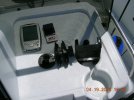
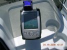
Seems that laptop computers are much more affordable, powerful and versitile as the main electronics "monitor" for a boat. Has anyone figured out a way to waterproof a laptop for a center console? I know there are increasingly more programs for which a laptop can take the place of stand alone electronics such as GPS and plotting, are there any others that are affordable? I have a feeling in 10 years, we will be using essentially a laptop for marine electronics instead of all the overpriced stuff we are stuck with now....maybe that's why Garmin and RayMarine are moving to sell waterproof monitors with plug and play electronic sensors.
 
Hi Molar. I was working on this idea last Fall as I've got some great GPS software with lots of fishing points on it. I was looking at the Panasonic "Toughbooks" laptop line. They are a bit pricey but very rugged and certain models in the lineup are waterproof. I was watching them on eBay for awhile hoping to pick up a deal on one, but then I got started working on this website and forgot about it. :) I agree with you that it would be very handy to have on the boat if it were small enough and tough enough. And with satellite broadband Internet service you'd could have realtime weather displays with radar off the Internet!
 
Yep, @5k with all the bells an whistles. I dream of the day when we just pop our big screen waterproof laptops onto the centerconsole, plug in a USB or two, and kabam....everything, sonar, gps, radar, live NexRad,internet and of course DVD burner. That day is upon us and bet all this is already availabe....for a price....in fact, it's all basic technology but no one comprehensive "brand" of system. Seems like Garmin and Raymarine are heading that way really fast and noticed in an ad how Furano has already incorporated charts, maps, plotting at part of the "network" which is laptop friendly. Just seems dumb to not design everything around a waterproof laptop which is so much more versitile and capable than the little screen stand alone products. Guess the market will have to drive it that way. I noticed the top of the line Panasonic Toughbook in the movie "Sahara" this weekend on the cigarette boat although it was not part of the "boat" electronics. Also didn't know that this is what is mainly being use by the US military in Iraq presently. Maybe the price may dip a bit with the increased volume.
 
Cool! How did you like Sahara? I haven't seen it yet. I need to go to a movie before carpel tunnel sets in. ;)
 
Don't forget bluetooth or 802.11b/g wireless to reduce all them wires. Anyone out there make software/hardware that will allow a transducer to connect to a laptop and get fishfinder capabilities? Am I just dreaming?
 
Whoa! That would be sweeeeet! Have to give that some thought and pass on to my IT friends. :)

Sea.P.A. said:
Don't forget bluetooth or 802.11b/g wireless to reduce all them wires. Anyone out there make software/hardware that will allow a transducer to connect to a laptop and get fishfinder capabilities? Am I just dreaming?
 
After my post I googled the software fishfinder and transducer and actually found one. Check this out http://www.cruzpro.com/ never seen it or heard of it but it looks like we are not too far away from my dream.
 
Laptop vs. Tablet PC

My own investigation into alternatives to my handheld GPS has led me to a Motion Computing Tablet PC, a RAM mount and a bluetooth GPS. When loaded with the proper marine software this would give a navigation computer, practically impervious to weather and shock, in a large enough (8x11 inch) screen that mounts horizontally or vertically, all with the added advantage of being removable. Taken home this would magically turn into a small home computer with wi-fi capabilities that you could enter routes into, etc., while sitting in your easy chair. At present a rig like this tops out at about $2,500.
It's the $2,500 that stops me since there's no doubt in my mind that the price of these things will start to go sharply down in the near future. At present I'm using a Dell Axim running Memory Map Navigator to do all of the above and except for the small size screen, it does everything I want it to.

In either case the RAM mount is what made the Dell usable when coming home from the Keys flats in rough water. Small is bad enough but small and bouncing all over...

MM
 
Great ideas Msmandel. Could you list specific model numbers that might make up a system like this? It might give members a springboard for pursuing something like this. :cool:
 
I have an Axim X30 with blue tooth and WiFi. Didn't think of bringing it on the boat though it seems a little fragile to me. Did you do anything to get it ruggedized?
 
reply to NCAngler and Sea. P.A.

to NCAngler: The tablet PC I've been eyeing is a Motion M1400. It can be had with a whole raft (pun) of accessories. I don't know if mentioning a vendor is permissable but if you go on to "Capn Jack" website (www.capjack.com) you'll see all the bells and whistles. I got the Memory-Map Navigator software from them and the SoftCharts. They are also amongst the nicest people I've ever dealt with and the most helpful. They actually talk me out of spending money. They were the ones who turned me on to the RAM E-Z Mount (custom made for the Dell Axim) that made the whole thing work for me.

to Sea.P.A.: There are another raft of protective sleeves that keep the Axim dry but I never bothered with them. I do not leave it on the boat when I come home. It's mounted deep enough near the windshield to protect it from most of the weather and spray and it's simple enough to wipe it off with a soft, damp cloth. As to the vibration damaging the device that's where the RAM mount comes in. They also have a website. It would take a two foot long description to explain how it's mounted and one glance at a picture to understand it. Can't get back on the boat for probably another 5 days because of the wind but if there's any interest I'll try to get a picture of my setup. It works great for me in the flats north of Key West. As a sophomore flats fishermen I'm not afraid of getting lost but of running aground as I pick my way through the minefield of shallows on the way to the fishing grounds.
The one negative is that the chart is always oriented North no matter what direction you're going in and the map is mentally "flopped" when you're coming South. I've already run aground once trying to go on the wrong side of a marker.

What makes the software great, however, is that I create the routes and edit them on my laptop and then download them to the Dell. This gives me archival storage in the laptop as well as in the Dell.

Hope this was informative and not too wordy.

MM
 
Great info MM. No problem mentioning vendors...helps us all out in finding the best products/solutions. I for one would love to see some pictures when you're back on the boat. And the problem of always being oriented North, I wonder if that could be a software modification that the software programs could make if enough interest was shown in their doing so? Good stuff! :)

msmandel said:
to NCAngler: The tablet PC I've been eyeing is a Motion M1400. It can be had with a whole raft (pun) of accessories. I don't know if mentioning a vendor is permissable but if you go on to "Capn Jack" website (www.capjack.com) you'll see all the bells and whistles. I got the Memory-Map Navigator software from them and the SoftCharts. They are also amongst the nicest people I've ever dealt with and the most helpful. They actually talk me out of spending money. They were the ones who turned me on to the RAM E-Z Mount (custom made for the Dell Axim) that made the whole thing work for me. MM
 
Photos of GPS

No. 1=Individual parts before assembly
No. 2=Ball Mount: Only part that is screwed onto boat
No. 3=Custom Holder for Dell Axim
Nos. 4 & 5=Entire contraption mounted.

Notes: 1. Forgot to get photo of accessory plug to use 12VDC point.
2. I don't know if color lines will show up but if they do:
Blue=Route created on laptop and downloaded into Dell. You can create a route directly on the Dell but using the laptop's larger screen makes it easier and creates an archive of route
Red=Vector of where you will be in 10 minutes (programmable) and is best way I found to stay on route. Ideally red will be superimposed onto blue.
Yellow=Track of where you have been. Can be converted to route. When I first started going out I had a more experienced person take me where I wanted to go. I then transferred track to laptop, converted it to a route, transferred it back to PDA. Sounds complicated, is not.

Software is almost infinitely adjustable and will show you several things I didn't want to know (e.g. ETA). I think you can download a trial from their website www.memory-map.com to try before you buy. Also the manual.

As for the complaint I had about the map always being North-South you can see that if you are going south while looking at such a map everything is reversed. Not normally a problem but if you have to make a sudden decision about a marker in the water you could (and I did) go on the wrong side of it. Kind of like stepping off a curb in London and looking the wrong way for the oncoming traffic.

Hope this is helpful. Any questions please don't hesitate to contact me.

MM
 

Attachments

  • Img0004.JPG
    Img0004.JPG
    116.8 KB · Views: 20
  • Img0006.JPG
    Img0006.JPG
    102.5 KB · Views: 17
  • Img0005.JPG
    Img0005.JPG
    117.8 KB · Views: 16
  • Img0001.JPG
    Img0001.JPG
    116 KB · Views: 24
  • Img0003.JPG
    Img0003.JPG
    122.9 KB · Views: 19
Laptops and boating...

Dude...I got a Dell...haha.

Really there are two options.

1. (Less expensive) go ahead and buy a Dell laptop and splurge the extra 350 or whatever they charge for the three year bumper to bumper on that bad boy. Then they have no choice but to replace it when that unforseen squall sets in and pours water on it. I just got back from Iraq and almost every Marine that was with me (including myself) had a Dell with that extra warranty. It covers everything from sand to shrapnel to wayward bullets. And more than one Marine has gotten brand new computers just from that warranty.

2. (More expensive) someone brought up the toughbook by Panasonic. They even brought up that we use them in the Desert. That is a big yes. But if yu can afford to drop the coin on a laptop of that caliber go ahead they are worth the money. The ones we used were a little slower than our personal laptops but the durability is insane. I for one (accidentally) drop one from a moving humvee. Once I brushed the sand off it fired right up and let me do my thing.

Best of luck with your decision,
Mike

Also any of you coming to Hawaii any time soon and want to get together for a dive/fishing? I should be getting my boat this week (210cc) and would love to take one of you guys out on it so you can show me all the little things that will take me a long time to learn. By the way this site is great and definately made my mind up about getting the Triumph. Happy Holidays.
 
Congratulations on the 210 Island_Diver! Wish I could take you up on that trip to Hawaii but I don't forsee it in the near future. You should have a blast with the 210 out there. Must be awesome fishing waters.

Good word on the laptops. I've got a new 215 Chaos ordered for Spring delivery and I'll be making decisions on the next couple months on electronics. I'd love to have GPS, Fish finder, radar, etc. connected to a Panasonic toughbook via bluetooth or something like that but not sure we're there yet and whoever gets there first gets to do the R&D at premium price. :) Of course I've been on the "bleeding edge" of computer technology for 15 years now so I know what that feels like. :p

Just wanted to thank you for your involvement on the site and congratulate you on the new boat. Hey if you haven't already take the poll about performanceoutdoors.net. It will help us attract advertisers and eventually be able to offer some deals to our membership through the Premium Member if the responses are strong.

http://www.performanceoutdoors.net/forums/showthread.php?t=1022

Merry Christmas!
 
Garmin Did It...

Well all it looks like Garmin may have done it. This is a little setup that costs waaaaay less than a GPS unit and essentially turns your laptop into a chartplotter. Now if it would only include the sounder capabilities I would be all set. I think that I am going to go with the 198c though. But here is the link if you all would like to take a look at it.

Have a good one,
Mike

http://www.westmarine.com/webapp/wcs/stores/servlet/product/10001/-1/10001/246713/10001/10803/48/3
 
Hard Drives are Problematic

Hey guys, I'm kind of in the laptop business. I make the mini wireless network adapter cards that go into many laptops/portables. The major reliability issue with today's technology in mobile computing is the hard drives. There is a disk inside that spins up to 7200 rpm and it does not take much to get them off tack and cause damage to the storage media. Even the ruggedized laptops will have this issue. On boats our size I think we'd have a reliability problem and would not trust a laptop as main source for navigation.
 
Good point Mario.
 
As we speak, the minds at APPLE are putting all this and more in the new waterproof marine iPOD/waasGPS/Sounder/XMweather receiver all on a 1" color screen!
The whole nation's streets and info will be included for the base price with Garmin BlueCharts available for fishermen at $200 per "hotspot" but you will have to buy their BlackBox sounder for $300 and their expansion hub for $300 and their transducer for $200 and pay $30/month subscription for XMWX. Oh yeah, to activate your subscription, there is a single startup charge of $50, haha!
Darn you Garmin and XM!
 
Back
Top